Introduction
Unlike other modes of transport, inland navigation makes use, at least in part, of a primarily natural infrastructure. The Rhine, like all rivers, thus evolves over time, be it as a result of natural and climatic phenomena or human intervention.
Since its foundation, the Central commission for the Navigation of the Rhine (CCNR) has been interested in the profile of the navigable Rhine waterway. Indeed, the CCNR has been involved in discussions regarding minimum water levels since 1839. In 1849, the CCNR even organised the first ever voyage from Basel to the sea for the purpose of monitoring levels.
Throughout its history, the CCNR has sought to optimise the use of the Rhine as a navigable waterway, while at the same time respecting the environment. Thus, the Rhine as a navigable waterway and the Rhine as a natural space that must be protected are two complementary aspects for inland navigation.
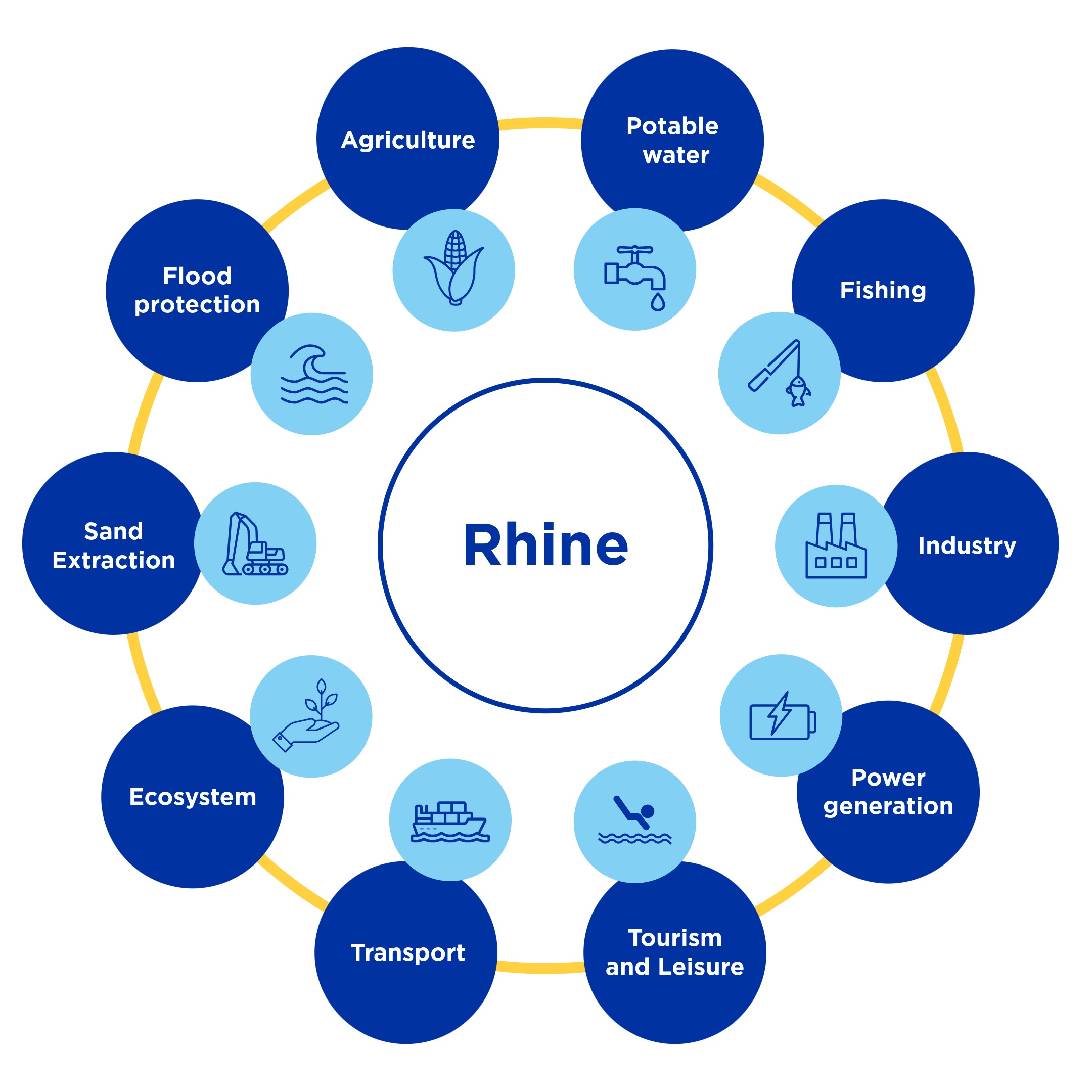
The diagram below illustrates the various users and uses of the Rhine.
As well as infrastructure in the conventional sense, the CCNR monitors the availability of all the equipment needed to ensure the smooth flow of navigation (RIS, berths, adapting infrastructure for loading and unloading, ship/shore interface, etc). It also takes an interest in the ecological management of infrastructure and the effects of climate change on the Rhine as a waterway, as well as questions concerning the availability of the navigable waterway. Although the CCNR has no major decision-making power in this area, it plays an important role in all matters related to infrastructure.
Currently, the work of the CCNR focuses on a number of areas:
- The Rhine as a river infrastructure (see above)
- Information relating to infrastructure work
- Climate change
- Low water
- The protection of the environment
The CCNR, especially its Infrastructure and Environment Committee, responsible for environmental and infrastructure matters, work closely with:
- The Permanent International Commission for Navigation Congresses (PIANC), in particular its Environmental Commission and its navigation working group.
- The International Commission for the Protection of the Rhine (ICPR), and its working groups on floods and low water (WG H) and water quality/emissions (WG S).
- The International Commission for the Hydrology of the Rhine basin (CHR), in particular with regard to climate change.
- The European Federation of Inland Ports (EFIP), in particular with regard to shore-based infrastructure in ports.
Characteristics of the waterway
Determining the equivalent water level
The current in the river means that the riverbed is continually changing. This has a direct impact on the depth of water available for river traffic in the fairway.
The first calculation of the minimum average depth was carried out by the CCNR for the period 1839-1848. Discussions on the determination of the water depth continued for several years in order to set the conditions for fixing the water level. In 1849, the Central Commission organised an initial monitoring voyage from Basel to the sea for the purpose of determining available and desirable water depths.
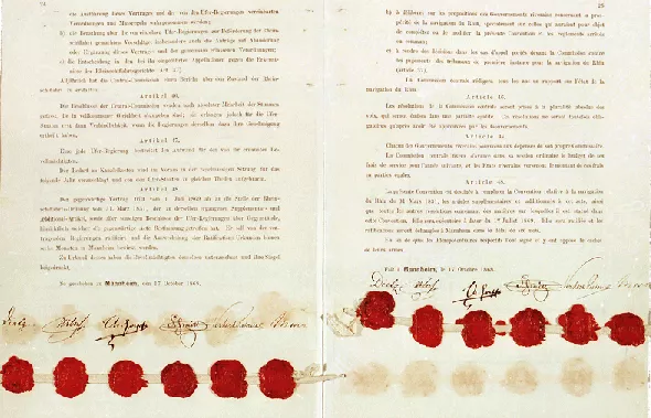
This practice was formalised in the Mannheim Act

 , whose Article 31 states that “From time to time hydraulics engineers delegated by the Governments of all the riparian States shall conduct surveys to examine the state of the river, to observe the results of measures taken for its improvement and to note new obstacles which impede navigation. The Central Commission will designate the period and the stretches of the river where these surveys shall be carried out. The engineers shall report to it on their results.” Currently, this function is carried out by the national authorities responsible for waterway management, who then report to the CCNR Committee responsible for environmental matters and infrastructure.
This concept formed the basis for determining the equivalent water level, which was measured and fixed regularly (1908, 1923, 1932, 1946, 1952, 1962, 1972, 1982, 1992, 2002, 2012 and 2022). The next fixing of the equivalent water level is due to take place from 2030, under the auspices of the CCNR.
Fixing the reference water levels is based on the following principles:
- The values of the equivalent flows (GlQ) at the reference gauges are re-determined every ten years in terms of the flows recorded over 100 years;
- The values of the equivalent flows form the basis for fixing the corresponding values for the equivalent water level (EWL) at the reference gauges. This is also carried out every ten years;
- The EWL is thus defined as, “The equivalent water level (EWL) is the water level occurring along the Rhine at an equivalent water flow falling below the long-term average for 20 days without ice [per year]”.
The ELW 2022 entered into force on 1 January 2023 and will remain valid until 31 December 2031, The EE for the following gauges has been fixed at:
Switzerland
- Bâle : 501 cm
Germany
- Maxau : 372 cm
- Spire : 237 cm
- Mannheim : 155 cm
- Worms : 68 cm
- Mayence : 171 cm
- Oestrich : 92 cm
- Bingen : 97 cm
- Kaub : 77 cm
- Coblence : 77 cm
- Andernach : 91 cm
- Bonn : 142 cm
- Cologne : 139 cm
- Düsseldorf : 91 cm
- Ruhrort : 227 cm
- Wesel : 174 cm
- Rees : 118 cm
- Emmerich : 74 cm
Netherlands*
- Lobith : 733 cm
- Pannerdensche Kop : 700 cm
- Nimègue : 516 cm
- Tiel : 255 cm
- IJsselkop : 683 cm
* The values for the Netherlands are in cm + NAP (Normaal Amsterdams Peil).
Further information about the equivalent water level can be found in Resolution 2022-II-19.
Water levels at the gauges relevant to Rhine navigation
The current water levels can be found here.
Profile of the Rhine fairway
The profile of the Rhine waterway, and especially the fairway, are primarily determined by means of survey The Rhine has a fairway with a guaranteed minimum depth of between 1.90 and 3.00 at equivalent water level.
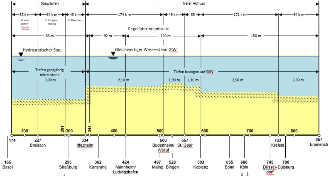
Dimensions of the Rhine fairway (Source: WSV)
Further information on the profile of the Rhine waterway can be found here: .
It is not always possible to keep to the profile set for the fairway (width, depth). Information on the restrictions affecting the width and depth of the Rhine in Germany can be found here.
In addition, the maximum permitted dimensions of vessels, pushed convoys and other assemblies of craft are set out in Chapter 11 of the Police regulations for the navigation of the Rhine (RPR).
Vertical clearance for bridges
Delegations inform the CCNR of the vertical clearance of bridges on the Rhine. This information is included in reports issued by the CCNR.
- Final report on vertical clearance for bridges in relation to the transport of containers stacked three layers high (Resolution 2001-I-28).
- Bridge clearance heights (2020).
Vessel berths
The CCNR monitors the question of berths available for inland navigation vessels along the length of the Rhine.
It is responsible for drawing up guidelines on the desirable number and quality of berths in line with changes in vessel traffic.
In September 2023, the CNNR published a report on berths entitled “A compilation of examples and guidance on the requirements for berths and the facilities needed.” (3rd edition).
In addition, a list of projects relating to shore power supply was published at the end of 2025.
Lastly, the CCNR regularly organises workshops on the subject of berths. The most recent were held in 2018 “Workshop on berths as element for a future-oriented inland navigation” and in 2022 “Workshop on shore power for berths”.
Information provided by Member States on navigation conditions and water levels
Germany
Elwis: here the German authorities provide 4 and 14 day forecasts for certain Rhine water levels relevant to navigation. In some cases, these forecasts can extend up to 6 weeks.
PEGELONLINE : https://www.pegelonline.wsv.de
National Flood Portal : https://www.hochwasserzentralen.de/
Belgium
Flanders, Waterinfo : https://www.waterinfo.be
Wallonia, Hydrométrie : https://hydrometrie.wallonie.be/
Brussels, Hydria : https://hydria.be/fr/carte-interactive-des-sites/
France
Vigicrues : https://www.vigicrues.gouv.fr/niv2-bassin.php?CdEntVigiCru=3
Netherlands
Waterinfo : https://waterinfo.rws.nl
Fairway information : https://vaarweginformatie.nl
Switzerland
Port of Switzerland, Pegel : https://port-of-switzerland.ch/hafenservice/pegel/
In addition to the information provided by the CCNR Member States, the European platform EuRIS compiles information relating to the main European waterways: https://www.eurisportal.eu/.
Interruptions to navigation
The CCNR, whose mandate is to guarantee freedom of navigation on the Rhine, ensures that the Rhine waterway remains as accessible as possible.
However, certain types of interruption are inevitable. These are monitored closely by the CCNR.
- High water levels
Once a set level has been exceeded, river traffic is stopped (RPR, Article 10.01). It is worth noting that the impact of high water levels on the logistic chain is less significant than the effect of low water levels on navigation. This is because floods on the Rhine rarely last longer than a week. - Low water levels
Unlike during high water, there is no specific water level at which navigation is prohibited. It is the responsibility of each boatmaster to determine whether the vessel can navigate a particular section of the waterway despite the low water level. Further information on low water levels is available on the dedicated page. - Interruptions due to cultural or other events (e.g. “Rhein in Flammen”)
These localised interruptions are usually short, lasting only a few hours, and the dates are known well in advance. There are very few such events. - Interruptions due to police measures
Such interruptions are occasional and known in advance. They only happen two or three times a year, and usually last between 3 and 12 hours. - Interruptions due to an accident (e.g. interruptions following the accidents with the Excelsior or the Waldhof).
- Simultaneous closure of two locks
This really only affects the Upper Rhine. The interruption may be due to an accident, a maintenance issue or strike action. There are a maximum of one to five such closures per year, lasting from 3 to 10 hours.
There may also be exceptional interruptions to the operation of certain locks over the Christmas and New Year period (Upper Rhine and Lek). These are the subject of a resolution adopted by the CCNR is a plenary session. - Work on the waterway (e.g. construction of new bridges)
The CCNR is informed of any interruption to navigation and works with the competent national authorities to monitor the measures taken to minimise such interruptions as far as possible.
It also carries out a statistical analysis of the interruptions. On average, they amount to around a hundred hours per year, which demonstrates the very high reliability of the Rhine waterway.
The CCNR has established a clear procedure for informing shipping of interruptions to navigation (Resolution 2021-I-16).
Rhine ports
The Rhine has a large number of port infrastructure facilities.
The Revised Convention for Rhine Navigation (“Mannheim Act” ) includes various provisions concerning the Rhine ports.
Articles 8 to 10 relate to the free ports, i.e. warehousing areas which are not subject to customs duties. In the current context of free movement, these provisions have become obsolete.
Article 11 lays down that each of the riparian States shall designate for the whole of its territory the ports and unloading places where boatmasters shall have the right to discharge or to load a cargo. Boatmasters are not permitted to load or unload at other locations, unless they have special authorisation or in exceptional circumstances.
While these provisions in the Mannheim Act are primarily for customs purposes, they do require Member States to ensure that Rhine shipping has access to suitable loading and unloading facilities.
This obligation concerning loading and unloading locations is also mentioned in Article 27, para.1, of the Mannheim Act: “The Governments of the riparian States will ensure that in the free ports, as in all other ports of the Rhine, all necessary measures are taken to facilitate loading, unloading and warehousing of merchandise and that the premises and equipment allocated to them are maintained in good order”.
The rules governing ports are determined by national legislation. Conditions governing access to existing public port infrastructure may not discriminate on grounds of nationality. The principle of freedom of navigation does not preclude the imposition of port fees in return for services rendered. Article 27, paras 2 and 3 (relating to ports) state: “To meet the necessary costs of maintenance and supervision, an appropriate fee may be levied. Should the revenue from this fee exceed the amount of expenditure in question, the rate of said fee shall be reduced proportionally. However, this fee may be collected only when use has been made of the premises and equipment mentioned above”.
Bodies
The CCNR has established two bodies to deal with matters related to the Rhine as river infrastructure: the Infrastructure and Environment Committee (IEN) and the specialist Working group for infrastructure and environment (IEN/G).
The key tasks of the IEN Committee are to:
- Collect information relating to the physical characteristics of the Rhine waterway:
- Fairway profile;
- Bridge heights and vertical clearance.
- Determine the equivalent water level.
- Draft requirements applicable to the Rhine as a waterway and to monitor any work, measures and projects being carried out on the Rhine that may affect navigation (locks, ports, etc.).
- Examine possibilities for improving the quantity and quality of berths on the Rhine, in particular with regard to shore power connections.
- Analyse interruptions to navigation and propose measure to reduce them.
- Implement the “Infrastructure” element of the CCNR Roadmap for the reduction of inland navigation emissions.
- Analyse and study the impact of climate change (mitigation and adaptation) on the Rhine waterway. Develop recommendations to ensure the resilience of the Rhine waterway.
- Represent the interests of Rhine navigation in the work of the European Commission, particularly with regard to the implementation of the TEN-T Regulation.
- Cooperate with organisations such as PIANC, ICPR and CHR.
- Monitor the implementation on the Rhine of the Water Framework Directive and the Habitats Directives.
- Draw up a list of the Natura 2000 zones which affect the Rhine waterway.
- Deal with cross-cutting issues related to the environment, as well as basic questions concerning the sustainable development of inland navigation.
Every two years, the IEN Committee defines a work programme setting out the priorities and future tasks. The IEN Committee traditionally meets twice a year, in Strasbourg (see the meeting calendar).
Chair of the Committee: Ms Barbla ETTER, Commissioner for Switzerland
Secretariat: Ms Friederike STOCK, Administrator responsible for infrastructure, environment and dangerous goods
Further reading
Documentation
Adaptation of the international alert and communication procedure
Police regulations for the navigation of the Rhine